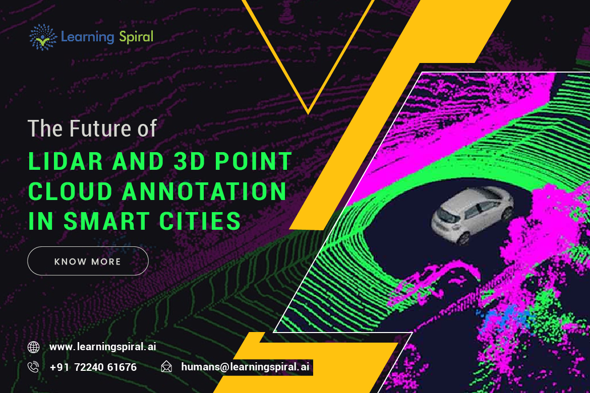
LiDAR (Light Detection and Ranging) technology has emerged as a cornerstone of modern urban development, providing detailed 3D point cloud data that captures the physical environment with unprecedented accuracy. Coupled with advanced annotation techniques, LiDAR data is playing a crucial role in building intelligent and sustainable cities.
In this article we will discuss the crucial aspects of LiDAR and 3D Point Cloud Annotation and its applications, especially in urban areas. 
Understanding LiDAR and 3D Point Clouds
LiDAR employs laser pulses to measure distances to objects, creating a dense point cloud representing the 3D geometry of a scene. These point clouds offer a rich source of information about the urban landscape, including building heights, vegetation cover, road infrastructure, and even individual objects.
The Role of Annotation
To unlock the full potential of LiDAR data, it must be annotated or labeled with meaningful information. This process involves identifying and classifying objects within the point clouds, such as buildings, trees, vehicles, and pedestrians. Annotated data is then used to train machine learning models for various applications in smart cities.
Applications of LiDAR and 3D Point Cloud Annotation
LiDAR and 3D point cloud annotation are driving innovation in several areas of smart city development:
- Urban Planning and Management:
Under this category, following usage comes:
- Digital Twins: Creating virtual replicas of cities to simulate urban development scenarios and optimize resource allocation.
- Infrastructure Assessment: Evaluating the condition of roads, bridges, and other infrastructure for maintenance and repair.
- Use Planning: Analyzing land use patterns and identifying suitable areas for development.
- Autonomous Vehicles: For vehicles, following applications are assisted by LiDAR & 3D Point Cloud annotation:
- HD Maps: Generating highly accurate 3D maps for autonomous vehicles to navigate safely and efficiently.
- Object Detection: Identifying and tracking objects in real-time for collision avoidance and traffic management.
- Environmental Monitoring: Taking care of our environment is also assisted in following manner:
- Vegetation Mapping: Assessing tree health, urban green spaces, and deforestation.
- Pollution Monitoring: Identifying sources of pollution and tracking air quality.
- Climate Change Adaptation: Evaluating the impact of climate change on urban infrastructure and developing adaptation strategies.
- Public Safety:
Annotation helps keep public safe in following ways: - Crime Analysis: Identifying crime hotspots and patterns using spatial data.
- Disaster Management: Assessing damage and coordinating emergency response efforts.
Challenges and Future Trends
While LiDAR and 3D point cloud annotation offer tremendous potential, several challenges remain:
- Data Volume: The sheer volume of LiDAR data can be overwhelming, requiring efficient storage and processing techniques.
- Annotation Complexity: Annotating complex urban environments, such as crowded streets or construction sites, can be time-consuming and error-prone.
- Data Privacy: Ensuring data privacy and security is a critical concern, especially when dealing with sensitive information.
To address these challenges, researchers are exploring innovative techniques such as automated annotation tools, deep learning algorithms, and data fusion with other sensor modalities. Additionally, advancements in cloud computing and edge computing are enabling efficient processing and analysis of large-scale LiDAR datasets.
Conclusion
LiDAR and 3D point cloud annotation are poised to play a transformative role in shaping the future of smart cities. By providing a rich source of data for urban planning, autonomous vehicles, environmental monitoring, and public safety, these technologies are empowering cities to become more sustainable, resilient, and efficient.
As LiDAR technology continues to evolve and annotation techniques improve, we can expect to see even more innovative applications emerge in the years to come.